
Hand-Hewn Highway: How the Beaten Path Came to Be
In part one of our blog series on the storied East Rosebud Trail, “What’s in a Name?”, we traced how this 27-mile route through the heart of the Beartooth Mountains came to be called “The Beaten Path.” For years, local Forest Service employees referred to it as “Beartooth 101” as a play on the busy US Interstate highway system. Then, in 1996, guidebook author Bill Schneider coined the name "The Beaten Path," which has since taken hold in popular consciousness of social media and the blogosphere, if for no other reason than it being a more catchy and convenient hashtag than “East Rosebud Trail #15 to Russell Creek Trail #3.” This installment is about how the route came to exist at all.
A Peak That Bears His Name
From its northern trailhead, The Beaten Path winds through the canyon created over millennia by the flowing waters of East Rosebud Creek. People have been moving through this canyon for thousands of years. The Crow and other Indigenous peoples knew this landscape long before westerners thought to document it, traveling routes shaped by the same terrain that would later challenge every explorer that followed. The written record begins much later.
In 1907, Fred Inabnit pushed farther into the upper drainage than any non-Native in the written record had gone. He pioneered a high route through what he called "the Snowbanks"— the glacier-strewn flanks of a peak that now bears his name. He made the first ascent of that summit and named a campsite "Flower Garden Park," which almost certainly refers to the small meadow along Five Mile Creek below the Giant's Belly, tucked between the Snow Lake basin and the rock walls overlooking Elk Lake and Box Canyon. It is the only flat ground in that entire stretch of country. The exact location remains one of several small mysteries this canyon has yet to fully give up. At 11,928 feet, Mount Inabnit is the 24th highest summit in Montana, and dominates the skyline between East Rosebud Lake and Elk Lake before the canyon bends and the higher peaks close in around you. Fred Inabnit was exploring, not trail-building, but the Snowbanks route he forged that summer was the key to everything that came next.
State records from Montana Fish, Wildlife & Parks (FWP) and regional archival documentation confirm rainbow trout were first stocked into 4th Lake (now called Rainbow Lake) in 1915, just six years after Inabnit’s exploration of the canyon and long before the first aerial stocking program began in 1948. Using the arduous “up and over” approach, this historic introduction was carried out by a small group of local homesteaders including John Branger, Sr. Like Inabnit, Branger was a Swiss native who immigrated to Montana and settled in the Beartooth Mountains because the dramatic alpine scenery reminded him of his homeland.
In 1921, Fred Inabnit started exploring past Rainbow Lake following the high route he had first navigated in 1907. Getting around the lake to the inlet proved so arduous that the party built a raft on the spot to float back across before making the march back over 10,000 feet to East Rosebud. The Columbus Times that same year reported there was still no horse trail past Elk Lake. A few years later Fred would traverse this route again as an approach toward his lifelong obsession: climbing Montana's highest point. True to Fred's Swiss heritage, these were mountaineering expeditions, uncommon among the local ranchers and sportsmen. He would eventually abandon the Granite Creek approach for the easier, if more circuitous, route via Froze-to-Death Plateau before his passing in 1928, never quite making it to the summit of Montana’s highest point despite playing a key role in the first ascent planning and logistics.
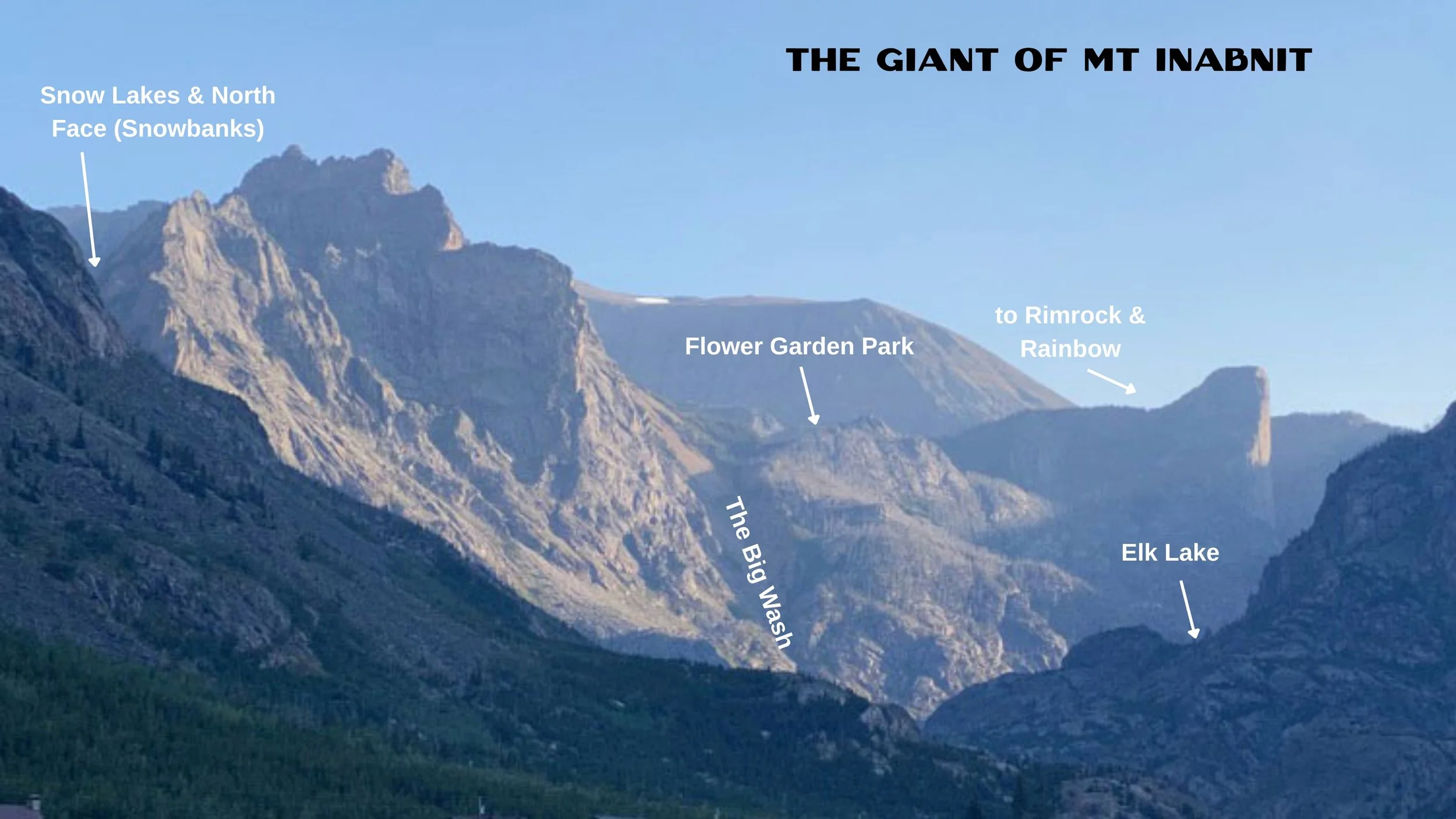
At 11,924’, the peak bearing the name of Fred Inabnit makes for a commanding presence.
What Inabnit's “Flower Garden Park” route bypassed entirely was the infamous outlet at 3rd Lake, now Rimrock Lake. A documented visit there came in 1930, when Glenn Saunders and his party navigated the torrent using logs and ropes, then waded along the far shore. The steep granite slabs hanging over deep green water are now etched with a wide blasted trail. How Saunders and his companion crossed those slabs is anyone's guess, but most people today wouldn't do it without sticky rubber shoes. Glenn's son Ralph will appear later in this story, as the publisher of the Rocky Mountain Survey maps in the 1980s.
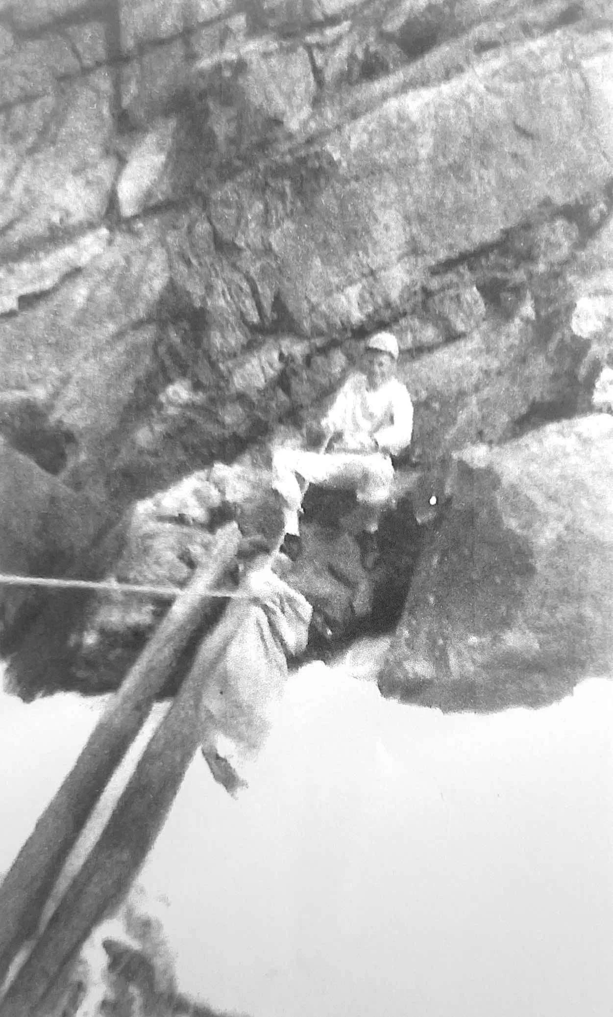
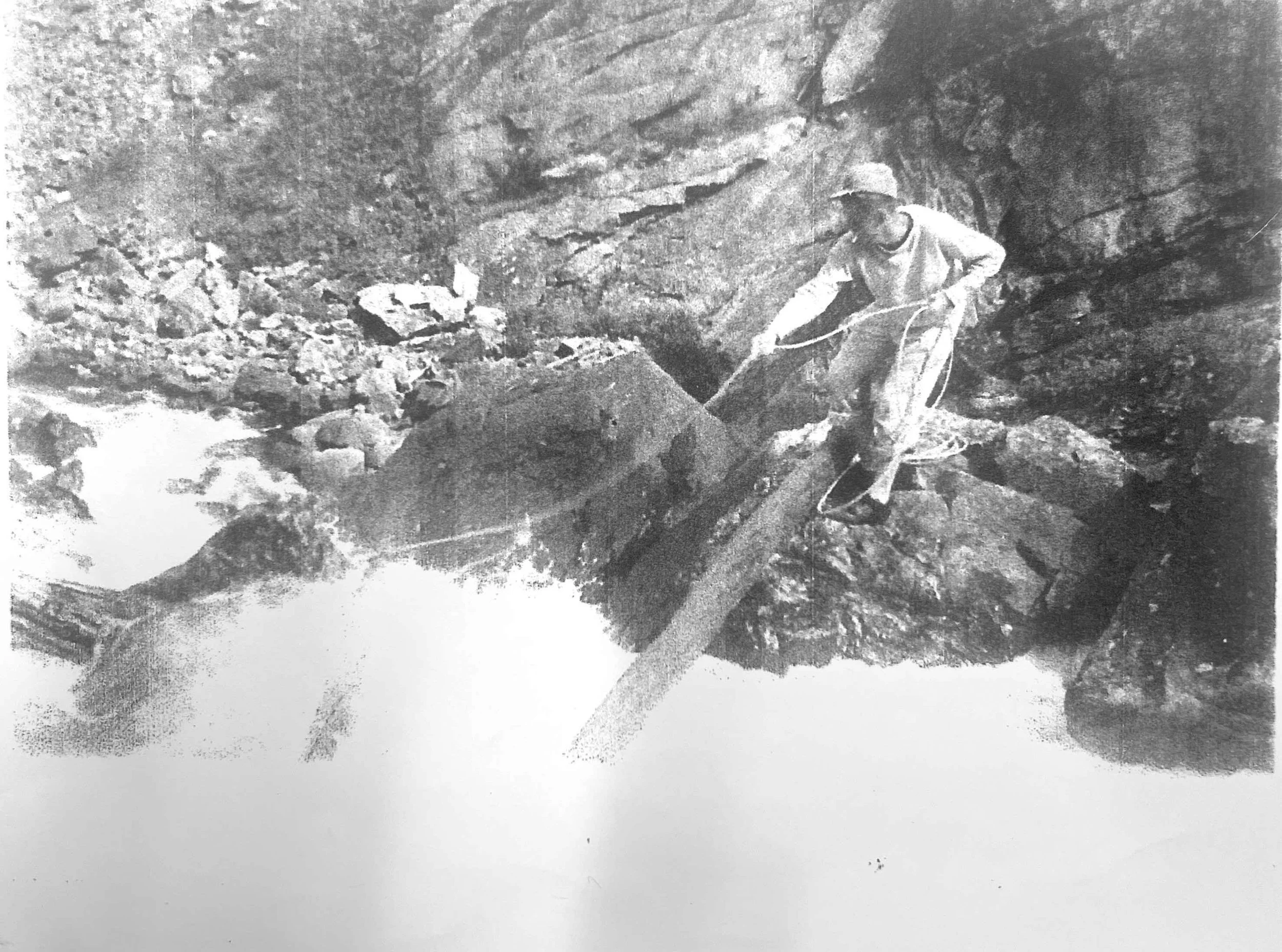
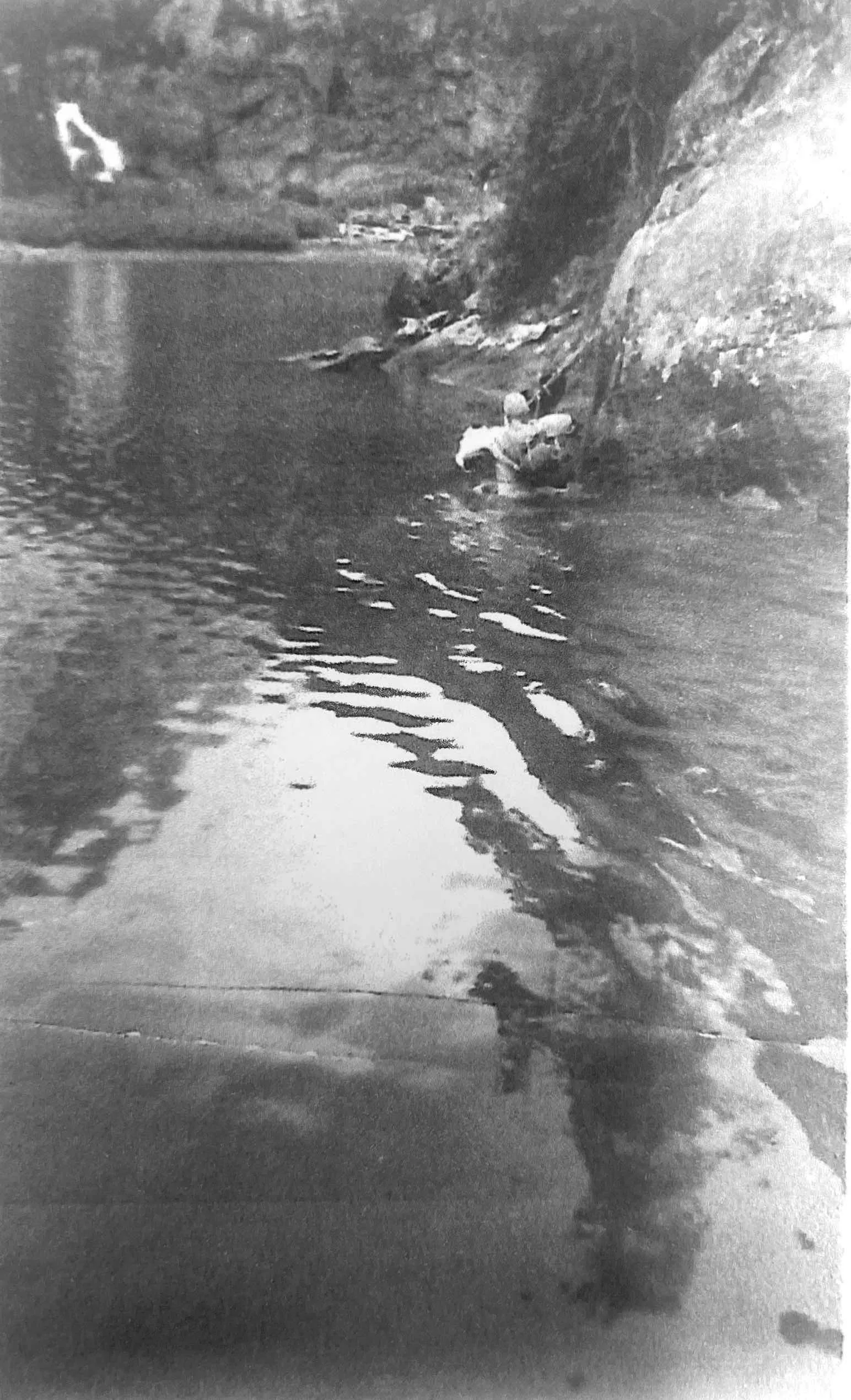
Photos by Glenn Saunders, courtesy Ralph Saunders.
Rainbow Lake, then and now, rewarded the effort. Large meadows and huckleberries line its shores and the fishing has drawn people for as long as anyone has been counting. Jim Annin, of the 1921 Inhabit party, reported in the newspaper of catching "a four pound rainbow on a royal coachman.” Annin, a local photographer and historian, indicated that Rimrock and Rainbow may have had trial stockings as early as 1909. For many years a cabin stood somewhere on the north bench for those who made it that far, its origins (most likely the Brangers), its occupants, and its eventual disappearance another thread in the canyon's still-unfinished history. When a horse-accessible trail to Rainbow Lake was finally established, it formalized what explorers had understood for decades: this was a destination worthy of the journey.
Building Toward Rainbow
Some reports claim the Civilian Conservation Corps pushed the trail to Rainbow Lake in “the late 1940s,” yet the CCC was disbanded in 1942. It was most likely Forest Service crews in the late 1940s or early 50s. The sections through Box Canyon near Broadwater and around Rimrock Lake required blasting near-vertical cliff faces, the kind of work that left impressive horse-accessible tread chiseled into rock just above the waterline. These are not long sections—typically less than 100 feet of blasted trail or just a set of switchbacks etched across a brief cliff face or rock slide—but they are remarkable engineering given their location, and they hold up today.
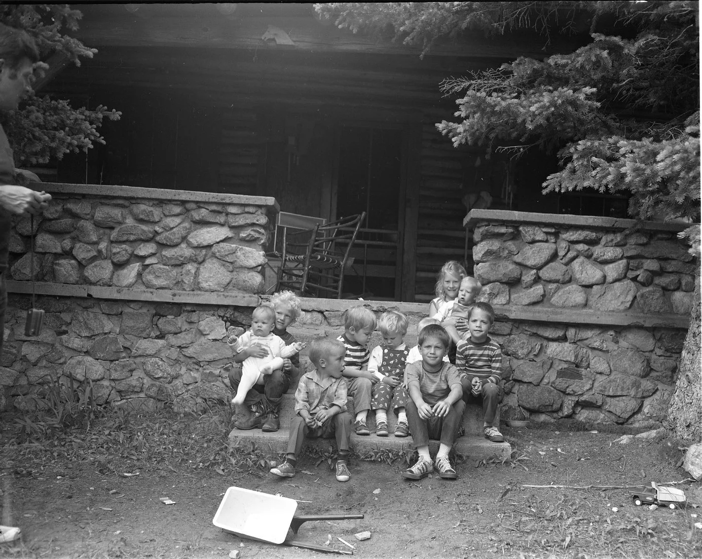
By 1952, the new trail supported serious pack trains. My grandfather and the artist Leroy Green spent a month at Rainbow Lake that summer, packing in canvas tents, cast iron cookware, and even a rubber raft with a gas motor. It’s unclear how the Hebgen Lake earthquake in 1959 impacted the East Rosebud drainage, despite burying nearby trails under massive rock slides and leaving lasting cracks in the porches of cabins at East Rosebud Lake. It undoubtedly delayed any new trail building as crews scrambled across the region to repair destruction. Above Rainbow Lake, there was still no formal trail…yet.


All photos by Harriet Josephson, courtesy of Joe Josephson.
Three Summers in Granite
In 1962, Forest Service trail crews launched what would become a three-summer effort to push the route through the upper canyon above Rainbow Lake. The scale was substantial: miles of new tread through Precambrian rock, with sustained blasting required to create passage around Impasse Falls and toward the high divide. Contemporary images from the time tell another part of the story: heavy snow and frozen lakes well into July, and the first snows returning in September. The crews had only a few short months each summer to make progress. Chuck Martin led the drilling operations above Impasse Falls until he was drafted to Vietnam. In what would become one of the most consequential moments for the trail as we know it, a Korean War veteran named Blase DiLulo stepped into that role after Martin’s departure and carried it forward.
According to the “shavetail ranger” Hank Rate, the crews consisted of “a twelve man wilderness construction crew that included a powder monkey (old hard-rock miner), a cook, a packer, two four-man squads, each comprised of two rock drillers (suspended from ropes, using gas-driven jack-hammers) and two muckers, a mechanic to keep the drills pounding, and Blase.” Of Blase, Rate continued:
“He knew every man’s job and taught the youngsters what they needed to know, down to the use of a back-country forge to maintain the hand tools. He led this crew on foot in and out of camp every 10 days. Morale was always high, and the young guys worshipped Blase.”
Blase would stay connected to this drainage until 1992, when he retired as a decorated US Forest Service Wilderness Ranger and Fire Boss. Blase’s role in this story is such an important one that we’re dedicating another installment of this blog series to it—stay tuned.
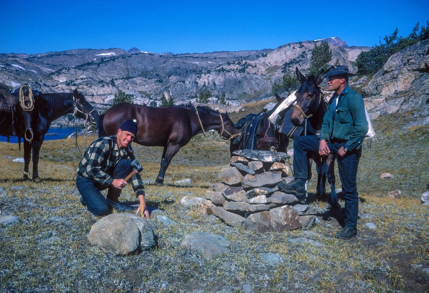
A brief photographic record of those three summers comes from Hank Rate. Hank had arrived in the spring of 1959 as a junior forester with the Forest Service, newly assigned to the Billings Office. In the years before construction began, he conducted recreation site inventories from the Stillwater drainage to the Dakotas. It is not unreasonable to wonder whether it was during those surveys, moving through country no one had yet committed to building trails in, that he began to see what the East Rosebud drainage could become.
When the crews went to work in 1962, Rate was with them, carrying Kodachrome slide film through each of the three construction seasons. His wife, Dorine Graham Rate, was there too, working as packer and camp cook for the crew pushing tread through the upper canyon. The photographs Rate made during those summers, shared with us by his daughters in Gardiner, Montana, are among the most vivid records we have of this place in the process of becoming what it is.
Rate would go on to serve as Stillwater District Ranger, heading what he considered the last year-round truly rural ranger station in the region before it was consolidated into the Red Lodge District of the Custer National Forest, a distinction he was proud of. He wrote about his years in this country in a piece called "Around the Beartooths in 80 Years," found in “Voices of Yellowstone’s Capstone,” an atlas containing a remarkable collection of essays, history, and photography documenting the greater Yellowstone region, available through the ABWF web shop. The story is largely about Dorine and her family, but it traces the arc of a career spent in close service to this landscape.
The Impasse. And the Choice.
Navigating difficult terrain often requires choice. The section of trail from Rainbow Lake past Lake at Falls and on toward Impasse Falls could have been routed around via a more gradual, treed drainage leading into Granite Creek and ultimately the high divide. Hank Rate and the crew chose to go through the rock anyway.
Lake at Falls is one of the most stunning sites in the entire Absaroka-Beartooth Wilderness: a deep blue alpine lake fed by multiple slender waterfalls dropping steeply from a hanging basin nearly into the lake itself, with a high altitude backdrop that stops you cold. The crews built a reinforced trail along the lake because they believed the public should be able to see it. That is a decision worth acknowledging, not just a series of routing choices, but a statement about what they knew this trail would become.
They made a similar choice at what is today called Duggan Lake. When a blast sent car-sized boulders airborne, splashing down in the unnamed tarn below, someone declared, “Boy, that was a duggan.” The name stuck. Hank Rate's Kodachrome slides include images of those very rocks in mid-air. It is a remarkable record of work that was as spectacular as it was dangerous.

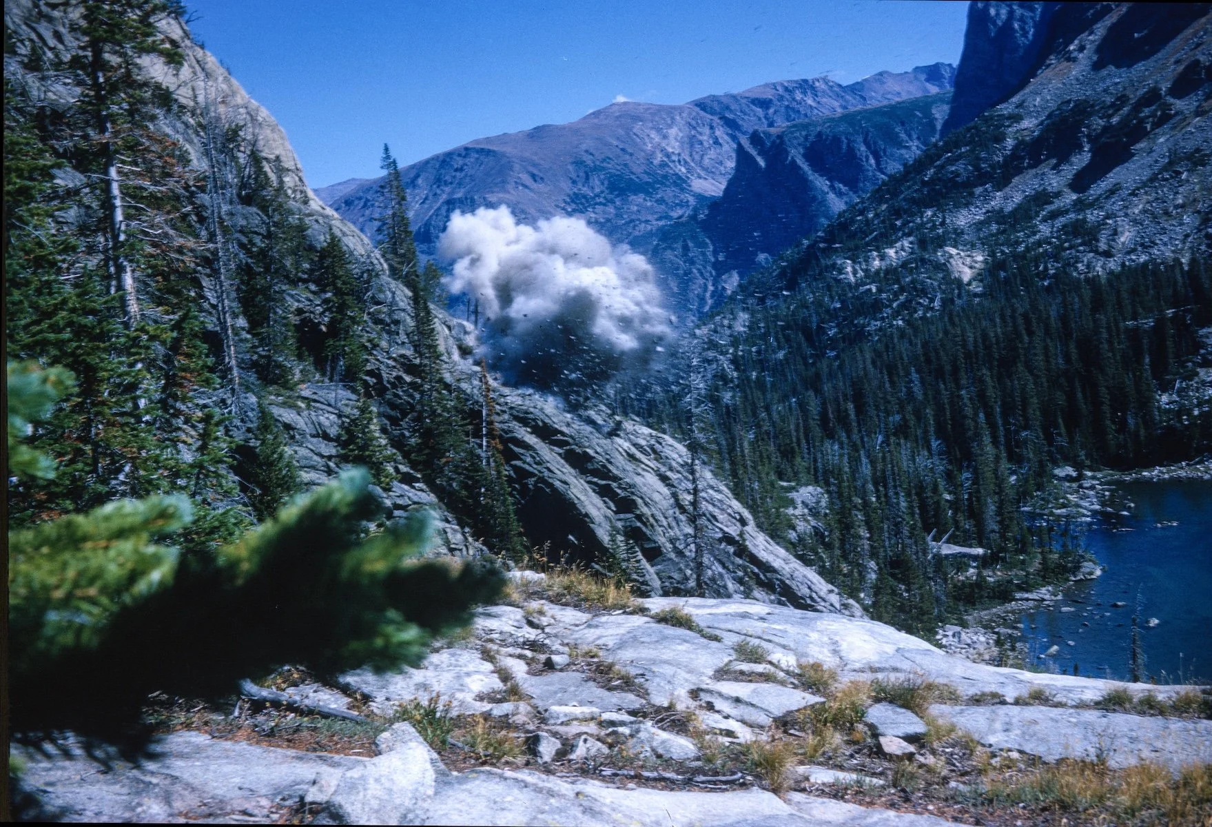

Trail-building is not for the faint of heart. Photos by Hank Rate.
Impasse Falls drops the full picture into focus. It slides down a glacial headwall like an extreme waterslide for over 100 feet before plunging directly into Duggan Lake. A look at Google Earth makes clear that an easier line existed above: higher ground across sparsely treed benches, bypassing the difficulty entirely. Instead, the crew built three major switchbacks and a rising traverse directly into the cliff to the brink of the falls that many consider the highlight of the entire trail.
From Impasse Falls, the route ascends past stunning sub-alpine lakes to the Fossil Divide. Twin Outlet and Dewey Lakes are among the most scenic on the entire trail, with commanding views of waterfalls replaced by glaciers clinging to the northern ramparts of the Beartooth Plateau. The Fossil Divide itself is a wide and relatively gentle crossing, rare in the Absaroka-Beartooth Wilderness, where the rugged character of the lower canyon gives way to long views in every direction. On a clear day you can see the Tetons. It is an unusually forgiving pass for such a hard range.
September 1964
By September 1964, the route was complete through the upper East Rosebud drainage, linking up with established trails near Fossil Lake. Trails on the Cooke City side had been in place for years, the product of easier terrain and decades of sportsmen's use during the New World Mining District era. The connection made the through-route possible, and someone drove a painted spike into the shallow tundra to mark the meeting of trails.
It was, in any reasonable telling, the trail's own golden spike.
With the driving in of a golden spike, the merging of trails makes a new on-trail wilderness through-route possible.
What the Wilderness Revealed
The new trail grew popular fast. By the time the Absaroka-Beartooth Wilderness was formally designated on March 27, 1978, the evidence of that popularity had accumulated beyond what anyone had planned for. In 1979, Forest Ranger Tom Alt recorded more than 125 fire rings around Rainbow Lake alone, while entire meadows near Elk Lake were trammeled to dust. Along with help from some Girl and Boy Scouts, Tom packed out 35 twenty-gallon bins of trash in that first season.
I'll say it plainly: some of that garbage may have been my grandfather's generation's doing. His 1952 trip to Rainbow Lake predated the wilderness act, the Leave No Trace movement, and any serious reckoning with the long-term cost of unguided use in fragile alpine terrain. He wasn't careless by the standards of his time:there were simply different standards.
Blase DiLulo had helped build the trail that made all of that use possible.He and Tom Alt looked at what unguided use had produced and started building something different: an ethic. Their "No Trace Camping" program reached thousands of school children across southern Montana at a time when minimal-impact wilderness travel was not yet a mainstream conversation. According to Tom, the entire effort rested on three things: signs at the trailhead, education programs in the community, and a wilderness ranger presence in the backcountry.
If that sounds familiar, it should. Those three pillars are the architecture of what ABWF does in this drainage today: our Ambassador-in-Residence program at each trailhead, our stewardship work in the backcountry, and the community education work that runs year-round. We didn't invent this approach:we inherited it from people who had also built the trail we're protecting.
Their full story, including what Blase did with a handful of strawberry plants at Rainbow Lake, is coming in part three. If you want a head start, Marci Dye's "Education of a Wilderness Traveler” from the “Voices of Yellowstone’s Capstone” atlas tells Blase's story in his own words. It is worth reading before we continue. You can purchase a copy of the atlas here or ask for it at your local bookseller.
Stewardship and Appreciation
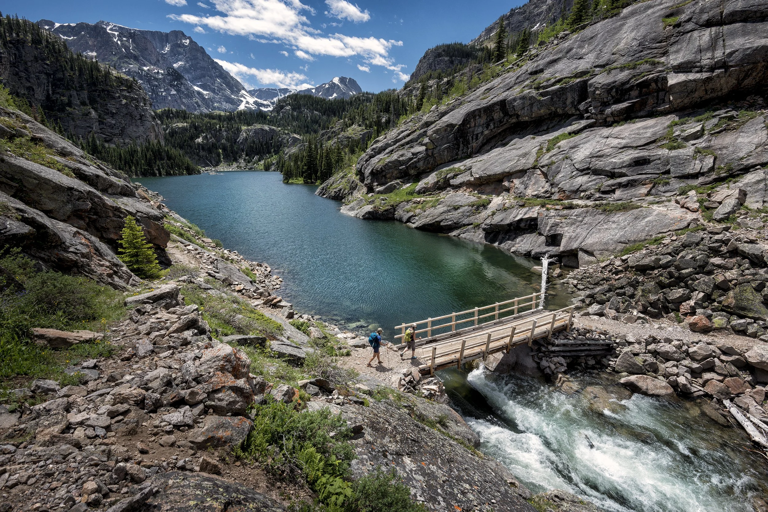
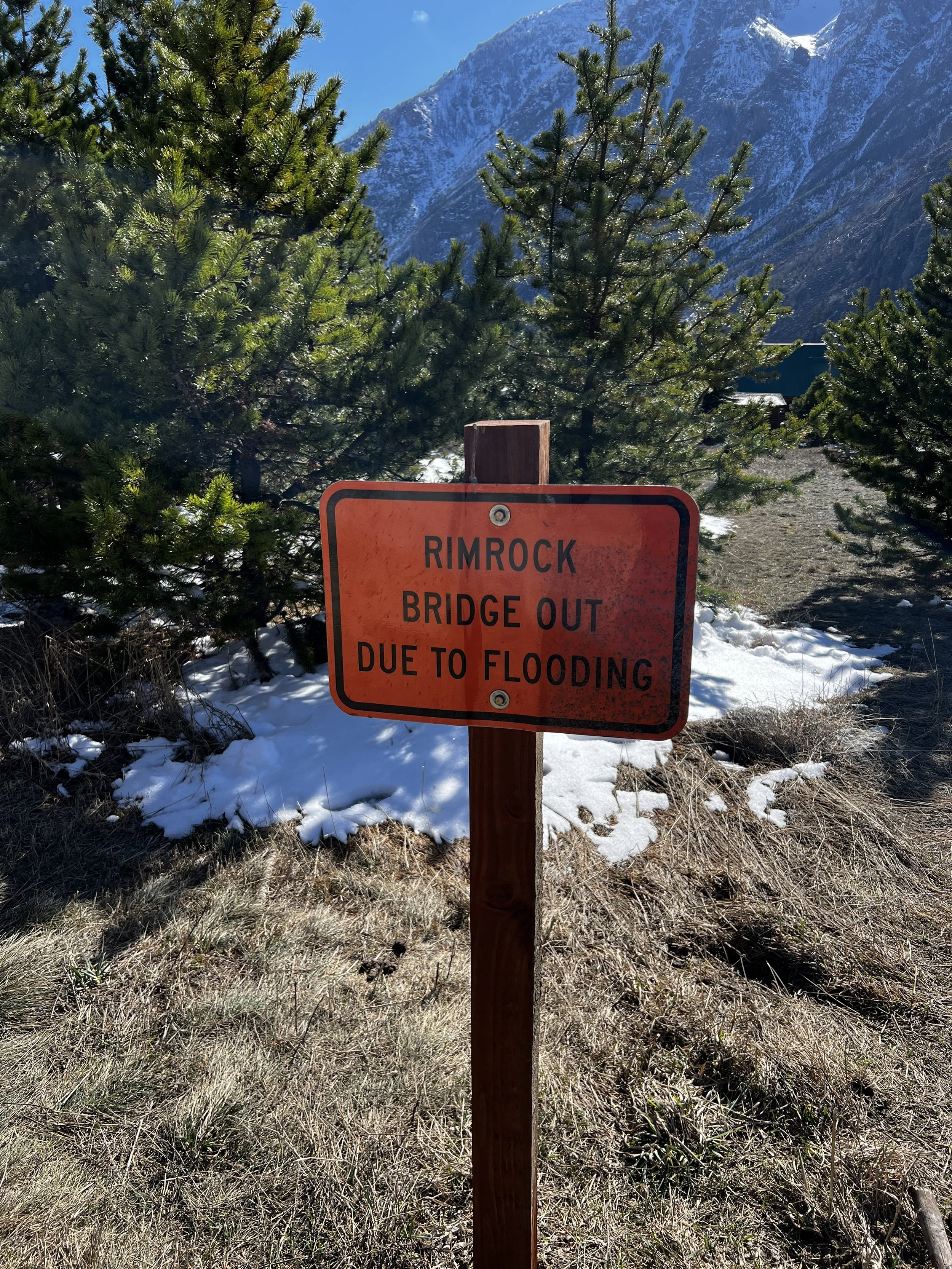
When roughly four and a half miles of trail and two miles of road were destroyed in the floods of 2022, East Rosebud Trail #15 and Russell Creek Trail #3 were temporarily made much more difficult to navigate, not unlike what Fred Inabnit and others experienced over 100 years ago. Replacing the washed out bridge at Rimrock Lake in October 2025 was another ‘golden spike’ moment, 61 years after the first: with that key linkage restored, the route once again became an on-trail through-route. Of course this time, instead of Wrangle-wearing workers transporting supplies and equipment with mules, this linkage used lumber-hoisting helicopters and OSHA-approved PPE. Although the character of the times constantly change (some might hesitate to call it an evolution), keeping the trail open and keeping it wild requires a similar commitment, made again every generation.
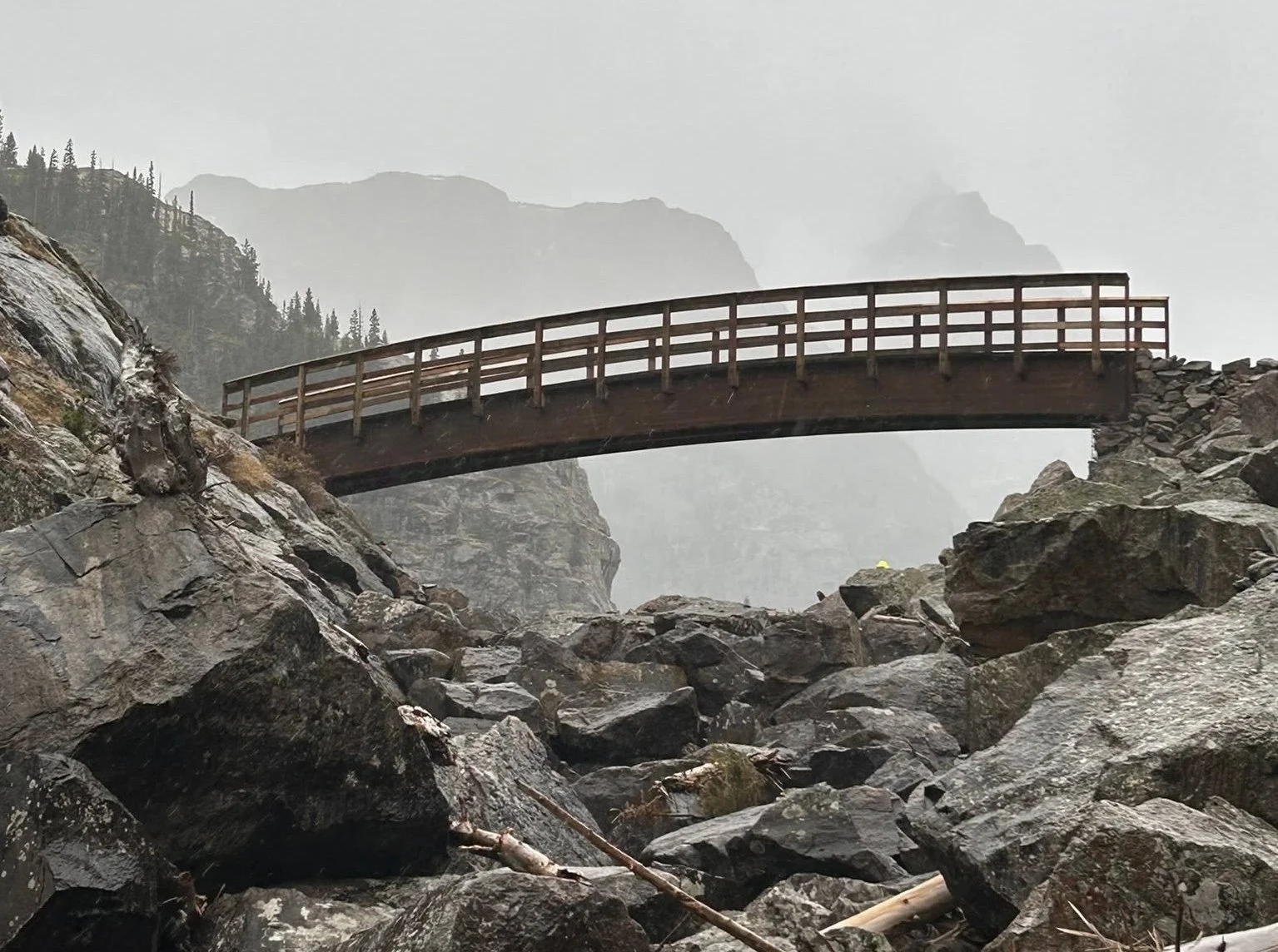
The new Rimrock Lake Bridge soars over the seasonally treacherous outlet of Rimrock Lake.
Our Future, Our Responsibility
So here’s my ask, friends: When you next find yourself on The Beaten Path, this summer or in the years to follow—whether it’s for a day hike, a run across the top, or for a week-long backpack—take a few moments of contemplation along the way. Move your gaze from the high ridge-lines and remarkable vistas to the trail itself. Think about the generations of explorers and workers who threaded the needle and pioneered the way and what traversing that rock slide, or getting past that bluff, might have been like without the trail. Consider the planning and skills laid down, literally in stone. Notice the drill holes and radial blast marks where men used explosive force with such precision, the perfectly incised line left behind is more engraving than trail. Do this, and I promise, a new appreciation takes hold. And along with that promise is my guarantee that the expanded richness of your experience across The Beaten Path will far exceed the satisfaction of any number of likes or comments you can muster through any social media post of this bucket-list trail, no matter how striking the view.
ABWF's 2026 stewardship program includes four trail crews working The Beaten Path this summer, plus Ambassador-in-Residence volunteers at both the East Rosebud and Clarks Fork trailheads. The Forest Service used explosives to build this trail—today we only ask you to carry a trowel (or use a wag bag), minimize and maintain fire rings, and secure your food and smellies to keep "The Beaten Path" from becoming truly beaten.
It may have taken crew of particularly intrepid folks to build this trail, but it takes the efforts of all of us to maintain it.
Follow ABWF for updates on an upcoming photo exhibit of Hank Rate's historic images—many never seen publicly before—coming this summer and fall to The Base Camp in Billings, Sylvan Peak in Red Lodge, and other locations near you. Stay tuned.
Gratitude to Tom Alt, Ralph Saunders, Wendy Rate Thomas, Becky Rate Johnson and the staff at Museum of the Beartooths in Columbus, MT for their research assistance.
Author and ABWF Executive Director Joe Josephson (front left) on the steps of the family cabin at East Rosebud Lake.